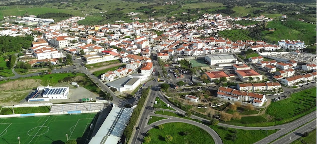
Friday, February 12, 2021

BALEIZÃO (PORTUGAL)


BALEIZÃO
38º 01' 32'' N; 7º 42' 52'' W

Baleizão is a Portuguese parish in the municipality of Beja, in the Alentejo region, with an area of ​​139.74 km² and 902 inhabitants (2011). Its population density is 6.5 inhabitants / km².
Catarina Eufémia was shot dead on 19 May 1954, at Monte do Olival, a place in this parish. She was an agricultural worker and a Communist Party activist who, following a strike by rural wage earners, was killed with three shots almost point-blank, from behind, by an agent of the Republican National Guard. At the age of twenty-six, illiterate, Catarina had three children, one of whom was eight months old. It offered resistance to the Salazar regime, being an icon of resistance in the Alentejo.
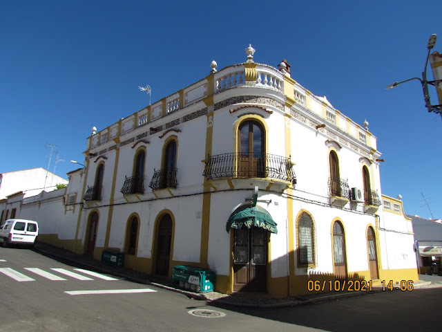
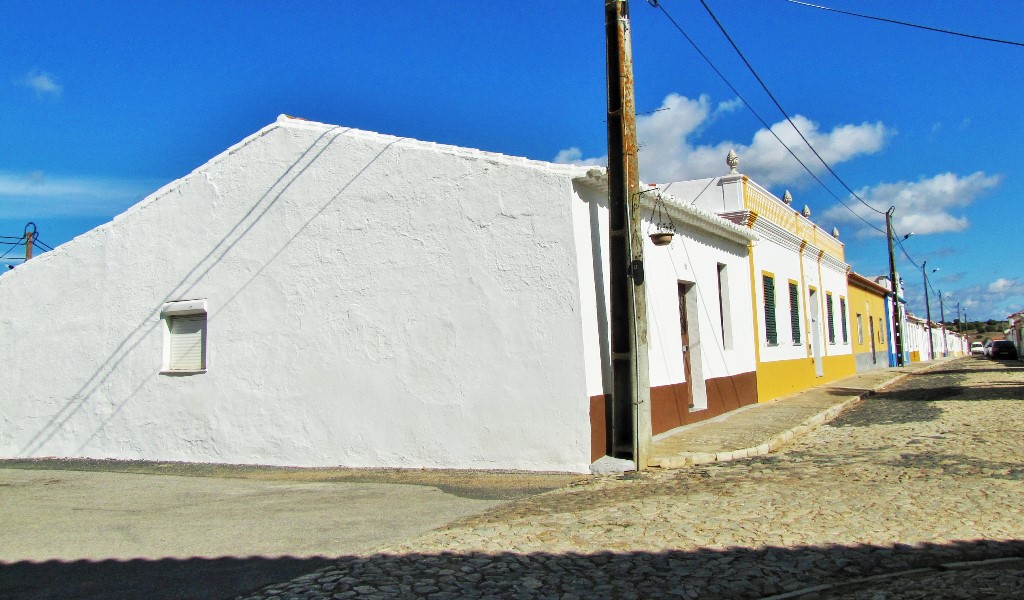
The village of Baleizão is described as follows in the work Anatomy of the Martyrs of João Tordo: "It is a set of white houses with brown brick roofs, stonework windows and extraordinarily small doors where, in the afternoons, the places take shelter from the heat. a school, a Parish Council and, in the center of the village, a bust of Catarina Eufémia on a white column surrounded by a small fence where, at the end of the afternoon, the old people sit and rest.
There are three cafes in this round. (...) I walked at random through the streets of hot tar and the low doors, of pruned orange trees and stray dogs sniffing the shoulders. "


💓💓💓💓💓

BACK TO INDEX OF 
DISTRICT OF BEJA

 MÉRTOLA;       SERPA;     MOURA;
 CASTRO VERDE;         ODEMIRA
 ALJUSTREL;            VIDIGUEIRA
  CUBA;                        AMARELEJA;
ALVITO;                            OURIQUE
BERINGEL;                 ALMODÔVAR;
BARRANCOS;                  BALEIZÃO;

💓💓💓💓💓

BARRANCOS (PORTUGAL)


BARRANCOS
38° 07′ 50.64″ N, 6° 58′ 33.97″ W

Barrancos is a bordering Portuguese village in the district of Beja, Alentejo region and sub-region of Baixo Alentejo. This village is the seat of the homonymous municipality and the homonymous parish of Barrancos, which both have 1435 inhabitants (2021).
The municipality of Barrancos, being one of the six municipalities in Portugal made up of a single parish, has the smallest population on the Continent and the third least populated in Portugal, with an area of ​​168.42 km².
The municipality/parish of Barrancos is bordered on the north and east by the Spanish municipalities of Oliva de la Frontera and Valencia del Mombuey (province of Badajoz) and Encinasola (province of Huelva), on the south and west by the municipality of Moura and on the northwest by the municipality of Mourão. It is 110 km from the capital of the district of Beja and the same from the city of Évora.

Climate
The municipality has a type of Mediterranean climate, with a dry period of around 80 to 100 days, during the summer, where the average temperature varies between 29 °C and 31 °C. In winter, temperatures are low (2 °C on average).
The average annual temperature is 16.2 °C in Barrancos. The average annual rainfall is 563 mm
.


💓💓💓💓💓

BACK TO INDEX OF 
DISTRICT OF BEJA

 MÉRTOLA;       SERPA;     MOURA;
 CASTRO VERDE;         ODEMIRA
 ALJUSTREL;            VIDIGUEIRA
  CUBA;                        AMARELEJA;
ALVITO;                            OURIQUE
BERINGEL;                 ALMODÔVAR;
BARRANCOS;                  BALEIZÃO;

💓💓💓💓💓

ALMODÔVAR (PORTUGAL)


ALMODÔVAR
37° 30′ 41″ N, 8° 03′ 37″ W

Almodôvar is a Portuguese municipality belonging to the district of Beja, Alentejo region and sub-region of Baixo Alentejo, with about 7,449 inhabitants.
The municipality of Almodôvar, headquartered in the homonymous village, has an area of ​​777.88 km² and 7,449 inhabitants (2011), subdivided into 6 parishes (Aldeia dos Fernandes; Almodôvar and Graça dos Padrão; Rosário; São Barnabé; Santa Clara-a -Nova and Gomes Aires; Santa Cruz).
The municipality is limited to the north by the municipality of Castro Verde, east by Mértola, southeast by Alcoutim, south by Loulé, southwest by Silves and west and northwest by Ourique.
Its main wealth is cork, arbutus brandy, goat cheese and honey. The population here is dispersed and makes a living from these activities, which they develop in parallel with small-scale agriculture.

Climate
The climate has Mediterranean characteristics, with hot, dry summers and cold, low-rain winters. The thermal amplitudes are accentuated, denoting a continental character, which is accentuated as we head east, moving away from the regulatory effect of the Atlantic. The average temperature is 15.9 °C. The hottest month of the year is August, with an average temperature of 23.1 °C. The average temperature in January is 10.0 °C. It is the lowest average temperature of the entire year.
Rainfall is negligible, gradually increasing from north to south. In addition to the lack of rainfall, there is a strong seasonality in rainfall and a large interannual variability. The average annual rainfall is 576 mm.


💓💓💓💓💓

BACK TO INDEX OF 
DISTRICT OF BEJA

 MÉRTOLA;       SERPA;     MOURA;
 CASTRO VERDE;         ODEMIRA
 ALJUSTREL;            VIDIGUEIRA
  CUBA;                        AMARELEJA;
ALVITO;                            OURIQUE
BERINGEL;                 ALMODÔVAR;
BARRANCOS;                  BALEIZÃO;

💓💓💓💓💓


BERINGEL (PORTUGAL)


BERINGEL
38° 03′ 00″ N, 7° 59′ 00″ W

Beringel é uma vila portuguesa do município de Beja, na região do Alentejo, com 15,04 km² de área e 1 301 habitantes (2011). A sua densidade populacional é de 86,5 habitantes/km².
Localiza-se no extremo noroeste do município de Beja.


💓💓💓💓💓

BACK TO INDEX OF 
DISTRICT OF BEJA

 MÉRTOLA;       SERPA;     MOURA;
 CASTRO VERDE;         ODEMIRA
 ALJUSTREL;            VIDIGUEIRA
  CUBA;                        AMARELEJA;
ALVITO;                            OURIQUE
BERINGEL;                 ALMODÔVAR;
BARRANCOS;                  BALEIZÃO;

💓💓💓💓💓


OURIQUE (PORTUGAL)


OURIQUE
37° 39′ 00″ N, 8° 13′ 30″ W

Ourique is a Portuguese village in the district of Beja, Alentejo region and sub-region of Baixo Alentejo, with less than 2,000 inhabitants.
It is the seat of the homonymous municipality of Ourique with an area of ​​663.31 km² and 5 389 inhabitants (2011), subdivided into 4 parishes: Garvão and Santa Luzia; Ourique; Panoias and Conceição; Santana da Serra.
The municipality is limited to the north by the municipalities of Santiago do Cacém and Aljustrel, to the east by Castro Verde and Almodôvar, to the south by Silves and to the west by Odemira.

Climate
In climatic terms, the region has two well-defined annual seasons: winter is cold and little rainy and summer is very hot and dry, the latter with temperatures that frequently exceed 40 °C. Because of this, the climate can be designated as a Mediterranean regime; on the Köppen-Geiger climate scale it is classified as Csa.
Rainfall is low (annual average of 558 mm), with irregular rainfall regimes and large variations from year to year. The driest month is July and has 2 mm of rainfall. With an average of 86 mm, January is the month with the highest rainfall.
The average annual temperature is 16.4 °C. The hottest month of the year is August, with an average temperature of 23.4 °C. The average temperature in January is 10.6 °C, which is the lowest average temperature of the year.


💓💓💓💓💓

BACK TO INDEX OF 
DISTRICT OF BEJA

 MÉRTOLA;       SERPA;     MOURA;
 CASTRO VERDE;         ODEMIRA
 ALJUSTREL;            VIDIGUEIRA
  CUBA;                        AMARELEJA;
ALVITO;                            OURIQUE
BERINGEL;                 ALMODÔVAR;
BARRANCOS;                  BALEIZÃO;

💓💓💓💓💓

AMARELEJA (PORTUGAL)


AMARELEJA
38.20960º N; 7.22776º W

Amareleja is a Portuguese parish in the municipality of Moura, in the Alentejo region, with an area of 108.34 km² and 2 027 inhabitants (2021) with headquarters in the homonymous village of Amareleja.
It is famous for its constant record maximum temperature (47.4 °C). For many years, until the 20th century, because of its area, it was considered the largest village in Portugal. Wine, white sheep's cheese and local black pork are part of Amareleja's cuisine. The parish once had the world's largest solar power plant. It is close to Alqueva, the River Ardila and the Castle of Noudar.


💓💓💓💓💓

BACK TO INDEX OF 
DISTRICT OF BEJA

 MÉRTOLA;       SERPA;     MOURA;
 CASTRO VERDE;         ODEMIRA
 ALJUSTREL;            VIDIGUEIRA
  CUBA;                        AMARELEJA;
ALVITO;                            OURIQUE
BERINGEL;                 ALMODÔVAR;
BARRANCOS;                  BALEIZÃO;

💓💓💓💓💓